Mission Trails Regional Park is hands down my favorite place to hike when I’m in need of a quick, convenient, and easily-accessible trail in San Diego. Not only are there miles of trails in this regional park, there are also an abundance of short trails that take you along a rushing river, through forests of sycamores, willows, and juncus trees, and atop picturesque peaks. Perhaps the best introductory hike in Mission Trails Regional Park is the Visitor Center Loop Trail, a relatively flat 1.5-mile loop that circles around the 14,575-square-foot visitor and interpretive center. Because of the relative ease of this hike, it is a great introduction to the outdoors for beginners, elderly hikers and children.
The trailhead for the Visitor Center Loop starts at the Jackson Street overflow parking area. Head past the masses of cars towards the rolling hills and you’ll find the first marked sign for the Visitor Center Loop Trail. Follow this trail away from the noise of the busy street and into nature. The trail will follow alongside the main park road towards the Visitor Center. Soon you will reach the road for the Visitor Center parking lot. Cross this road and follow the next trail marker for the “Visitor Center North Loop”.
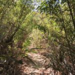
You will begin walking north alongside chaparral plants including laurel sumac, chamise, buckwheat, and chaparral broom. In the distance you will see South Fortuna Mountain, a more challenging trail you can eventually conquer at Mission Trails.
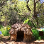
At 0.36-miles, a fork will turnoff to the riverside grinding site where bedrock morteros can be found. This site has historical significance as well, this is where the Kumeyaay would grind their seeds and acorns to prepare them for meals. You can turnoff here to walk the short distance to view the grinding area or you can continue the loop.
The trail will start to follow the river, with more riparian plants popping up on both sides of the trails. The noise of the river below is subtle, yet adds a nice ambiance to the already peaceful atmosphere found all throughout Mission Trails. At about 0.9-miles, you will encounter a turnoff for a trail that leads to Fortuna Mountain. Veer left and head up a somewhat steep hill. Here you will pass a small stream on your right. After the hill begins to taper off and flatten, you will find yourself back at the start at the Jackson Street parking area.
Visitor Center Loop Trail Tips
Tip #1: Before your hike, visit the award-winning visitor center to learn about how water was transported to San Diego and the rich history of the nation’s largest urban natural park. The visitor center is open daily from 9 a.m. to 5 p.m.
Tip #2: Bring your dogs along for this hike, however they must be on a leash.
Tip #3: Because of the relative easiness of this hike, this is also a great trail for runners, children, first-time hikers, and elderly hikers.
Tip #4: Check out the nearby Oak Grove Loop Trail to tack on another quick, easy hike.
Tip #5: Want to tackle a trail and make a difference? Take part in the monthly volunteer opportunities with habitat restoration, park beautification, and trail improvement efforts.
Driving Directions
From I-8 east, exit Mission Gorge/Fairmount. Follow the signs to turn right on Mission Gorge Road. Drive 4.2 miles and turn left for the Jackson Street parking lot. You’ve gone too far if you reach Father Junipero Serra Trail Road (however this trail can also be accessed by parking near the visitor center).
Elevation Gain: 571 feet
Difficulty: Easy
Total Distance: 1.5-Miles
Resources: Mission Trails Regional Trail Map